Missouri flooding forces dramatic rescues and campground collapse 2026
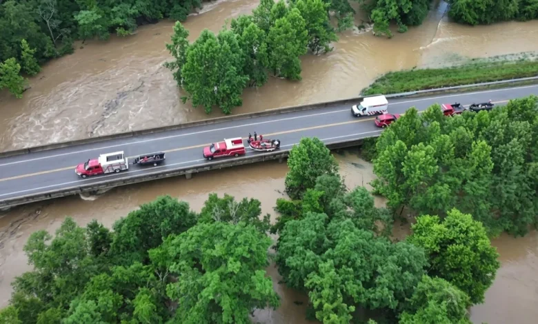
Table of Contents
Missouri flooding has transformed parts of southeast Missouri into a high-stakes disaster zone after a historic meteorological event unleashed relentless rainfall on Friday, July 10, 2026. Within a span of twelve hours, several rural communities were submerged as water levels climbed at unprecedented rates, trapping hundreds of campers, tourists, and local residents. Emergency response networks, coordinated by local sheriff’s departments, the Missouri State Highway Patrol, and specialized federal units like Missouri Task Force 1, worked tirelessly throughout the day to execute life-saving rescues under extremely hostile conditions. The scale of the deluge has triggered an immediate state of emergency, emphasizing the vulnerabilities of low-lying recreational areas situated along the region’s volatile river systems.
The Meteorological Breakdown of the July 2026 Deluge
A catastrophic atmospheric setup acted as the primary catalyst for this historical weather event. According to the National Weather Service (NWS), a stalled convective system aligned perfectly over the Ozark Mountains in southeastern Missouri. This phenomenon, often referred to as “storm training,” occurs when multiple thunderstorms repeatedly pass over the exact same geographical strip, amplifying rainfall totals exponentially in a short timeframe.
Meteorological data indicated that between eight and twelve inches of rain fell in less than twelve hours over portions of Reynolds, Iron, and Crawford counties. The sheer volume of water overwhelmed the regional drainage basins, resulting in what experts have classified as a 1-in-1,000-year rainfall event. Unlike typical seasonal storms, the persistent bands of intense precipitation saturated the soil instantly, triggering instantaneous runoff that cascaded directly into local creeks and riverbeds.
The Dramatic Collapse at Bearcat Getaway Campground
Perhaps the most terrifying incident of the entire weather event unfolded at the Bearcat Getaway Campground, located along the shores of the Black River in Lesterville. As water levels rose rapidly during the early morning hours, approximately twenty campers found themselves cut off from safety. Seeking refuge, the group climbed onto an elevated campground building, hoping to stay above the rising torrent. However, the relentless force of the surging Black River proved too great for the structure.
Sgt. Eddie Young of the Missouri State Highway Patrol confirmed that multiple agencies were alerted to the situation early Friday. The emergency calls highlighted a desperate scenario where a group of people, surrounded by roiling floodwaters, were trapped on top of a structure that was rapidly losing structural integrity.
Mechanics of the Structure Failure
The mechanics of the structure’s collapse highlight the devastating hydraulic force of rapid-onset flash floods. Sgt. Eddie Young explained at a Friday afternoon news conference that the building’s foundations were rapidly undermined by the raging waters. “Between the weight and the constant waters underneath it, it just gave away on them,” Young remarked.
The physical collapse plunged several individuals directly into the turbulent, debris-laden floodwaters, turning a localized rescue operation into a critical life-or-death crisis. Wood, metal, and recreational vehicles were swept into the current, presenting severe physical hazards to those struggling to stay afloat.
Swift-Water Tactics in the Black River Rescue
Despite the extreme danger, a coordinated rescue effort was launched almost immediately. The Reynolds County Sheriff’s Office, led by Sheriff Caleb McCoy, worked alongside state swift-water rescue personnel to navigate the treacherous currents of the Black River. Using specialized watercraft, rope rescue systems, and aerial observation, rescuers managed to pull all twenty individuals from the water.
In a testament to the skill and quick action of the first responders, every single camper involved in the building collapse was recovered safely. Additionally, five other campers who had been reported missing from the same facility prior to the collapse were located unharmed, bringing immense relief to families waiting for news.
Aerial Lifeline: Helicopter Evacuation of Camp Taum Sauk
While rescue operations were underway at the campground, another emergency was unfolding just miles away at Camp Taum Sauk. The private youth summer camp, nestled deeply in the Ozark forest near Lesterville, became entirely isolated when access roads were completely washed out by the overflowing tributaries of the Black River. More than 200 children, teenagers, and camp counselors were trapped as floodwaters encroached on the camp’s main campus.
Given the impassable state of local roads, ground transport was ruled out, forcing officials to authorize an aerial rescue campaign. The Missouri Army National Guard deployed Black Hawk helicopters to execute a massive airlift. Throughout Friday afternoon, the helicopters ran continuous shuttle flights, flying the children and staff to safety at a nearby elementary school, where they were successfully reunited with their families.
Hydrological Extremes: The Surging Black River
The behavior of the Black River during this event stunned hydrologists and local emergency planners alike. In the vicinity of Lesterville, the river exhibited a staggering vertical rise of eight feet in just one hour. It ultimately crested at an all-time record height of 28.7 feet, eclipsing previous historic levels and completely submerging adjacent floodplains.
This rapid rise is characteristic of the steep topography of the Ozarks, where rocky soil and narrow valleys act as natural funnels, accelerating runoff into major river channels. The extreme speed of the water’s rise left virtually no time for orderly evacuations of low-lying areas, which explains why so many campers and residents were caught off guard in the early morning hours.
Emergency Response and Political Mobilization
Recognizing the severity of the disaster, Missouri Governor Mike Kehoe took swift executive action by declaring a state of emergency across central, south-central, and southeastern Missouri. This formal declaration activated the State Emergency Operations Plan, enabling state agencies to rapidly coordinate assets and bypass typical bureaucratic delays.
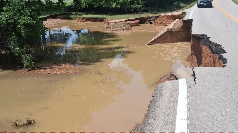
“With additional heavy rain expected through the weekend, the threat is not over,” Governor Kehoe warned in an official statement. “If you are camping, floating, or spending time near rivers and streams, move to higher ground immediately.”
The state emergency response included the strategic deployment of Missouri Task Force 1, a highly specialized urban search-and-rescue team managed by the Boone County Fire Protection District. Under the leadership of Ernie Rhodes, fifty members of the task force, along with swift-water rescue boats, drones, and canine units, were positioned in Reynolds and Iron counties to assist overwhelmed local personnel.
Operational Hazards: Capsized Rescue Boats and High-Stakes Logistics
The operational theater was fraught with extreme danger for the emergency personnel themselves. During the height of the rescue operations on Friday, two rescue boats carrying emergency personnel capsized in the turbulent currents. The incident highlighted the sheer unpredictability of swift-water environments, where hidden debris, hydraulic undertows, and rapid currents can easily overpower motorized vessels.
Fortunately, all safety workers aboard the capsized boats were recovered safely downstream by fellow emergency responders, preventing what could have been a secondary tragedy. This narrow escape underscored the immense personal risk assumed by the men and women serving on the front lines of the disaster.
Crawford County Displacement and Search for the Missing
While Reynolds County reported no major injuries or fatalities, the situation remained tense in neighboring Crawford County, located approximately 71 miles southwest of St. Louis. Emergency teams there reported that a house was swept entirely off its foundation by the raging floodwaters.
A local woman who was inside the residence at the time was reported missing, prompting an active search-and-rescue operation. Teams combed through the debris-strewn banks of the local waterways, battling high currents and muddy terrain. This incident stood as a sobering reminder of the destructive capacity of flash flooding, which is capable of tearing apart residential structures and permanently reshaping the local landscape. Much like the severe Kentucky flash floods that devastated communities in previous seasons, these rural emergencies pose unique rescue challenges due to limited cellular connectivity and remote geography.
Broader Environmental Context: A Pattern of Extreme Weather Events
The sheer intensity of the rain in southeastern Missouri fits into a worrying pattern of increasingly frequent extreme climate events observed across North America. As global warming continues to raise atmospheric temperatures, the air gains the capacity to hold more moisture—roughly seven percent more water vapor for every degree Celsius of warming. This shifting baseline creates conditions ripe for historic, high-intensity precipitation events that exceed the design specifications of existing civil infrastructure.
Simultaneously, the continent has witnessed a parallel rise in other environmental extremes, ranging from prolonged droughts to record temperatures that shatter historic records. These dual forces of extreme heat and concentrated precipitation suggest that the hydrological cycles of major American river basins are undergoing a profound and dangerous transformation.
Key Statistics of the Southeastern Missouri Flood Emergency
To understand the scope of the emergency, it is helpful to look at the primary metrics recorded during the peak of the storm on Friday, July 10, 2026. The table below outlines the hydrological and operational statistics compiled by local emergency services and the National Weather Service.
| Metric Detail | Recorded Value / Status | Primary Location / Agency Affected |
|---|---|---|
| Maximum Rain Accumulation | 8 to 12 inches | Reynolds, Iron, and Crawford Counties |
| Peak River Height (Black River) | 28.7 feet (Historical Record) | Lesterville, MO |
| Hourly River Rise Rate | 8 feet in 1 hour | Lesterville, MO |
| Camp Taum Sauk Evacuees | Over 200 children & staff | Missouri Army National Guard (Black Hawks) |
| Bearcat Getaway Campground Rescues | ~20 campers rescued | Reynolds County Sheriff / Highway Patrol |
| Total Water Rescues (County-wide) | Over 90 successful rescues | Reynolds County, MO |
| Emergency Responders Capsized | 2 boats (All crew safely recovered) | Black River swift-water operations |
| Active Missing Persons | 1 woman (Home swept off foundation) | Crawford County, MO |
Future Resilience and Infrastructure Vulnerabilities
As the floodwaters slowly begin to recede, attention is inevitably turning toward long-term recovery and systemic vulnerabilities. The geographic placement of commercial campgrounds, lodges, and seasonal youth camps in the immediate floodplain of the Black River must be critically evaluated. While these sites provide vital recreational and economic value to rural Missouri, their exposure to sudden, violent hydrological surges is undeniable.
Furthermore, local road networks must be engineered with larger culverts and higher bridge clearances to prevent the total isolation of communities during extreme rain events. For task forces like Missouri Task Force 1 and state highway patrols, the ongoing climate transition demands ever-increasing investments in swift-water training, drone reconnaissance, and inter-agency communication. Until these systemic upgrades are achieved, emergency responders will remain the final line of defense against an increasingly volatile environment.