Cold Front Triggers Extreme Wildfire Risk in the West 2026
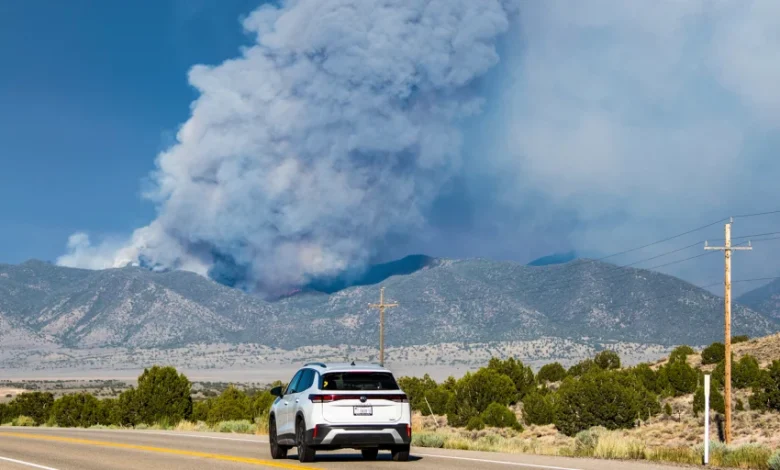
Table of Contents
Cold front dynamics are dramatically reshaping the wildfire landscape in the American West as a powerful low-pressure system moves inland. Forecasters expect the large cold front to develop in the Pacific Northwest on Thursday then push southeast into the Intermountain West, creating dry lightning along the storm’s leading edge. The lightning could spark fires, and powerful winds throughout the weekend could spread any new blazes while exacerbating others already burning. This rapid weather transition represents a critical period of elevated danger for states within the Great Basin and surrounding regions, where extreme heat waves have already primed dry vegetation to act as explosive fuel.
The combination of dry thunderstorms, fierce winds, and parched landscapes presents an exceptional challenge to wildland fire agencies. Historically, cold fronts are associated with cooler weather and moisture; however, when these fronts move across high-altitude deserts and mountain ranges, their precipitation evaporates before reaching the ground, leaving only dry lightning strikes and violent wind changes behind. Local emergency planners, state forestry divisions, and federal agencies are bracing for a highly volatile weekend that could permanently alter the current season’s fire trajectory.
The Impending Cold Front: Meteorological Overview
To fully grasp the magnitude of the incoming threat, one must understand the underlying meteorological conditions driving this system. The transition begins when cold, dense marine air from the Pacific Ocean pushes over the Cascade Mountains. As this air mass collides with the blistering hot, dry air of the interior basins, a sharp baroclinic zone forms. This zone, representing a stark contrast in temperature and pressure over a short distance, generates substantial atmospheric instability.
This instability forces the warm air upward rapidly, forming cumulus clouds that eventually grow into high-based thunderstorms. Because the air layer beneath these clouds is exceptionally warm and dry, rainfall evaporates during its fall through the lower atmosphere. The result is a thermodynamic engine that produces powerful electrical storms without the dampening benefits of rain. This creates a high risk of lightning moving across southern and eastern areas, particularly on Thursday and Friday, followed by several days of strong winds.
Development in the Pacific Northwest
Initial development of this massive cold front is scheduled for Thursday over the Pacific Northwest. In coastal regions, such as western Oregon and Washington, this system will bring beneficial rain, temporarily lowering the local fire risk. However, the Cascade Range acts as an atmospheric filter. As the clouds rise over the mountains, they lose most of their moisture on the western slopes. By the time the system reaches the eastern side, it is dry, windy, and highly volatile. The resulting downslope winds accelerate, creating a severe pressure gradient that begins to push aggressively into the dry interior regions.
The Southeast Progression into the Intermountain West
Progression of the cold front will accelerate southeastward, crossing into the Intermountain West by Friday morning. The Intermountain West—a region that includes parts of Arizona, Idaho, Nevada, Utah, and Wyoming—has already been baking under consecutive weeks of high temperatures. As the front marches southeast, the leading edge will act as a broom of electrical activity, sweeping across dry sagebrush plains and coniferous forests. Once the lightning strikes pass, the cold front’s pressure gradient will trigger high wind warnings across a multi-state region, turning any new ignition into a rapidly moving wildfire.
Understanding Dry Lightning and Its Volatile Leading Edge
Dry lightning remains one of the most unpredictable and dangerous sources of wildfire ignition in the Western United States. During these storms, cloud-to-ground lightning occurs while the air mass near the surface remains incredibly dry. This dryness leads to the evaporation of rain, a process called virga, which leaves dry fuels exposed to extreme heat discharges. When a lightning bolt strikes dry timber or dry cheatgrass, the high temperatures immediately ignite the fuel.
Without moisture to suppress the embers, these fires can smolder quietly for hours or even days before being fanned into active blazes. This is known as “holdover” fires, which can suddenly erupt when wind speeds increase. The leading edge of the storm front acts as a massive ignition wave, dropping hundreds of strikes across remote wilderness regions that are incredibly difficult for fire engines and hand crews to access quickly. The resulting pressure on aerial firefighting assets becomes immense as they attempt to locate and suppress dozens of new starts simultaneously.
The Winds of Danger: Extreme Weekend Windstorms
Fierce winds will dominate the weather story from Friday into the weekend. Forecasters expect a strong windstorm beginning Friday in Utah, Colorado, Arizona, Nevada, and New Mexico. The rapid transition from hot, stagnant air to cold, moving air generates a massive pressure gradient. Winds are projected to gust up to 40 to 50 mph, with some exposed ridges experiencing gusts exceeding 60 mph. These winds will not only drive the rate of spread for existing blazes but will also carry embers miles ahead of active fire perimeters, igniting new fires through a process known as long-range spotting.
Such extreme wind speeds make traditional firefighting methods nearly impossible. When winds exceed 30 mph, air tankers and helicopters are often grounded due to safety concerns and turbulent air currents, leaving ground crews to combat the blazes without aerial support. Glen Merrill of the National Weather Service in Salt Lake City has emphasized that Utah will likely see widespread gusts in the 40-50 mph range, making containment efforts highly complex and dangerous.
Regional Breakdown: Impacted Western States
The vast geographic area affected by this cold front means that various ecosystems will face different fire behaviors. The National Interagency Fire Center has elevated the preparedness levels in response to the looming storm. Each state in the Intermountain West presents a unique fuel profile, from dry fine grasses in desert basins to heavy timber at higher elevations, all of which are highly receptive to lightning-induced ignitions and rapid wind-driven spread.
Utah, Colorado, and New Mexico Outlook
In Utah, Colorado, and New Mexico, the fire danger is already extremely elevated. The Iron Fire near Eureka, Utah, has already demonstrated aggressive behavior, sending thick plumes of smoke into the sky. As the windstorm hits Utah and western Colorado, these active blazes are expected to experience rapid expansion. The National Weather Service has issued red flag warnings across these states, indicating that any fire that starts will likely grow out of control. Pinyon-juniper woodlands and heavy timber in southwest Colorado and northern New Mexico are critically dry, preparing the landscape for crown fires that can destroy entire forest ecosystems within hours.
Arizona, Nevada, Idaho, and Wyoming Risk Profiles
Further north and west, Arizona, Nevada, Idaho, and Wyoming are preparing for similarly dangerous conditions. Southern and eastern Nevada are particularly vulnerable to dry lightning strikes, which could spark fires in rugged terrain where roads are non-existent. In Idaho and Wyoming, the high-altitude forests of lodgepole pine and Douglas fir are suffering from historically low moisture levels. If lightning sparks fires in these heavy fuel beds, the weekend windstorm could drive fires through the forest canopy, creating intense, fast-moving blazes that pose severe risks to rural mountain communities and recreational areas.
Expert Analyses on Extreme Fire Behavior
Climate scientists and fire meteorologists are expressing grave concerns over the timing of this system. Basil Newmerzhycky, a forecaster for the Great Basin Coordination Center, warned on Wednesday that the region is looking at a high-risk scenario. “Friday into the weekend, overall fire danger is very high to extreme. Several of our fires are already showing extreme fire behavior,” Newmerzhycky stated during an online briefing. This assessment reflects the grim reality that fuel conditions are so dry that fires do not require high winds to burn aggressively; they are already doing so under stagnant conditions, and the incoming wind will only supercharge them.
Daniel Swain, a prominent climate scientist at UCLA and the National Center for Atmospheric Research, highlighted the historical oddity of this event. “It’s widespread, it’s going to be long in duration, and it’s going to be occurring at an unusual time of year for there to be long-duration widespread wind events, which is summer, during fire season and during a significant drought,” Swain observed. His remarks underscore that the sheer duration of the windstorm—lasting multiple days—will severely test the physical limits of firefighters and the containment lines they have worked tirelessly to build.
Wildfire Preparedness and Coordination Center Resources
The Salt Lake City-based Great Basin Coordination Center is actively coordinating the distribution of firefighting resources. This includes moving hotshot crews, heavy air tankers, and engines to strategic locations where dry lightning strikes are most likely to occur. Because multiple fires are already active, resource scarcity is a major concern. Fire managers must prioritize fires that threaten human life and critical infrastructure, leaving others in remote wilderness areas to burn under close monitoring.
Public cooperation is vital during this high-risk period. Residents in the affected states are being asked to adhere strictly to local burn bans and fire restrictions. Activities that could cause accidental sparks—such as target shooting, using chainsaws, or driving vehicles over dry grass—must be suspended. Emergency management agencies recommend that families living in fire-prone areas review their evacuation plans, pack emergency “go-bags,” and sign up for local emergency alerts to ensure they can escape quickly if a fire threatens their community.
The Science of Fire Weather Indices
To evaluate the potential severity of fire weather, meteorologists track the Energy Release Component (ERC). The ERC is a crucial fire weather index that represents the potential heat release per unit area at the leading edge of a spreading fire. Currently, more than half of the monitoring stations across the Great Basin are reporting ERC values that are at or near record-dry levels. This means that the moisture content of heavy fuels—like dead logs and deep forest floor debris—is incredibly low. When these fuels are dry, fires burn hotter, spread faster, and are far more difficult to extinguish.
Another key indicator is the 100-hour and 1000-hour fuel moisture levels. These metrics measure the dryness of dead forest materials of various sizes. When 1000-hour fuel moisture falls below 10%, forests are in prime condition for catastrophic fires. The incoming cold front, by dropping relative humidity to single digits while introducing strong mechanical wind forces, will push these indices into uncharted territory, creating conditions that are rarely seen so early in the summer fire season.
Impact on Firefighting Logistics and Resource Allocation
When a weather event of this magnitude hits multiple states simultaneously, it creates a logistical challenge of national proportions. The National Interagency Coordination Center must balance the needs of different geographic areas, such as the Southwest, the Great Basin, and the Rocky Mountains. If Utah, Colorado, Arizona, Nevada, and New Mexico all experience extreme fire starts on the same day, the demand for air tankers, hotshot crews, and incident management teams will quickly exceed availability.
This resource deficit requires strategic triage. Fires burning near towns, power lines, and municipal watersheds are given top priority. Meanwhile, fires burning in remote wilderness zones are often managed under a confinement strategy, where fire crews establish containment lines far back from the active fire edge and allow the fire to burn toward them. This approach reduces the risk to firefighters but can result in massive columns of smoke that degrade air quality across several states for weeks on end.
Strategic Comparison: Wind Speed and Lightning Forecasts
To help residents and local emergency services prepare, the following data table summarizes the forecast metrics for the upcoming weather event across the most critically threatened states in the Intermountain West.
| State / Region | Expected Wind Gusts (mph) | Dry Lightning Risk | Primary Fuel Type Concerns | Overall Fire Danger Rating |
|---|---|---|---|---|
| Utah | 40 – 55 mph | Extreme (Friday) | Cheatgrass, Sagebrush, Oak Brush | Extreme |
| Nevada | 35 – 50 mph | High | Pinyon-Juniper, Desert Grasses | Very High to Extreme |
| Colorado | 30 – 45 mph | Moderate to High | Coniferous Forest, Fine Fuels | Very High |
| Arizona | 35 – 45 mph | High (Southern/Eastern) | Chaparral, Ponderosa Pine | Very High to Extreme |
| New Mexico | 30 – 40 mph | Moderate | Mixed Conifer, Fine Fuels | High to Very High |
| Idaho & Wyoming | 35 – 50 mph | High (Eastern Idaho) | Heavy Timber, Lodgepole Pine | High to Very High |
As this multi-faceted weather event unfolds, close coordination between local, state, and federal agencies will be key to saving lives and minimizing resource losses. The physical limits of firefighting resources will be tested, making proactive community preparedness and total compliance with local fire bans the most powerful tools available to prevent disaster.