Mindanao Earthquake: 7.8 Magnitude Triggers Tsunami Warnings
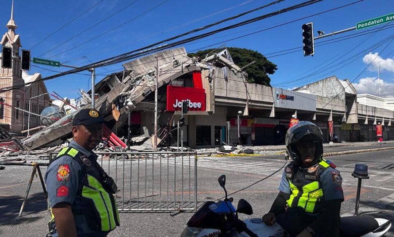
Mindanao earthquake events of June 8, 2026, have sent shockwaves across the southern Philippines and Southeast Asia, demonstrating the violent and unpredictable nature of the Pacific Ring of Fire. Registering at a massive magnitude of 7.8, the undersea quake violently shook the southern region of Mindanao at precisely 7:37 a.m. local time, causing panic among millions of residents, downing power grids, and prompting immediate, urgent alerts of an impending tsunami. The earthquake, which is the strongest to strike the archipelago nation in 2026, triggered massive geological and administrative responses across three nations: the Philippines, Indonesia, and Malaysia. As coastal populations scrambled for safety and civil defense teams deployed to assess structural damage, the event highlighted the critical importance of early warning systems and coordinated disaster mitigation in the Western Pacific region.
Anatomy of the Magnitude 7.8 Seismological Event
The massive offshore earthquake that occurred on the morning of June 8, 2026, was initially estimated at a lower magnitude before being officially upgraded. According to the Philippine Institute of Volcanology and Seismology, the tremor was formally classified as a magnitude 7.8 event. This adjustment represents a massive increase in energy release, explaining why the shock was felt so intensely across a vast geographic area. Seismic waves radiated throughout Mindanao and the neighboring Visayas islands, with high-intensity ground shaking recorded as far as Zamboanga and Leyte.
This earthquake was tectonic in origin, meaning it resulted from the sudden release of built-up strain along tectonic plate boundaries. The southern Philippines is characterized by complex geological interactions, where several microplates and major tectonic plates collide. In this specific instance, the fault displacement occurred along the southern portion of the Cotabato Trench, a major subduction zone located southwest of Mindanao. Here, the oceanic lithosphere of the Celebes Sea basin subducts beneath the Philippine Mobile Belt, making it a well-known breeder of highly destructive earthquakes and tsunamis.
Depth, Epicenter, and the Cotabato Trench Fault Line
The precise epicenter of the earthquake was located approximately 13 kilometers (about 8 miles) southwest of General Santos, a sprawling commercial center and port city on the island of Mindanao. Initially, conflicting seismological reports arose regarding the focal depth of the rupture. The Philippine authorities initially reported a relatively shallow focal depth of 10 kilometers (6.2 miles), which amplified the immediate panic regarding potential tsunami generation. In contrast, the United States Geological Survey and subsequent refined analyses placed the depth at approximately 33 kilometers (20 miles) below the seabed.
Such variations in focal depth estimates are common during the initial hours of a seismic crisis as regional and global networks reconcile real-time sensor data. However, whether the rupture occurred at 10 or 33 kilometers, the sheer magnitude of 7.8 meant that the displacement of the ocean floor was substantial. The vertical movement along the Cotabato Trench displaced cubic kilometers of water, instantly generating gravity waves that rippled outward as tsunamis. This geological mechanism explains the swift escalation of emergency protocols across coastal SOCCSKSARGEN (Region XII) and neighboring administrative zones.
Key Seismological Metrics and Impact Summary
To understand the sheer scale of the June 8, 2026 seismic event, it is helpful to look at the consolidated data collected by international and local geological monitoring networks. The table below outlines the core metrics, epicentral locations, and administrative alerts issued in the immediate aftermath of the rupture.
| Seismic Metric | Recorded Data & Observation Details |
|---|---|
| Date and Local Time | June 8, 2026, at exactly 7:37 a.m. local time |
| Upgraded Magnitude | Magnitude 7.8 (Upgraded from an initial estimate of 7.0) |
| Epicentral Coordinates | Offshore, approximately 13 kilometers (8 miles) southwest of General Santos City |
| Focal Depth | Varying reports from 10 kilometers (PHIVOLCS) to 33 kilometers (USGS/Revised) |
| Fault Origin | Tectonic slip along the active Cotabato Trench subduction zone |
| Maximum Tsunami Heights | Monitored peak waves of 1 meter (3 feet) locally; initial forecasts up to 3 meters |
| Casualty Toll | At least 12 fatalities confirmed, with over 200 injured across multiple provinces |
| Core Affected Areas | General Santos, Sarangani, South Cotabato, Davao Occidental, Sultan Kudarat |
Immediate Tsunami Threats and Regional Evacuations
As the ground stopped shaking, the immediate threat shifted from collapsing structures to the rapidly encroaching ocean. The Pacific Tsunami Warning Center (PTWC) in Hawaii issued a bulletin warning that tsunami waves up to 3 meters (10 feet) above tide level were possible along some coasts of the Philippines, particularly those closest to the epicenter. Furthermore, the agency noted that waves up to 1 meter (3 feet) could impact coastal communities in northern Indonesia and eastern Malaysia.
The warnings prompted immediate panic and massive, self-evacuating movements of populations in low-lying coastal zones. Within minutes of the quake, social media feeds were flooded with videos of receding coastlines—a classic precursor to a tsunami—and sirens blaring across coastal towns in Sarangani, Sulu, Davao Occidental, and Sultan Kudarat. Tsunami waves measuring up to 1 meter (3 feet) were eventually confirmed to have washed ashore in the provinces of Sultan Kudarat and Sarangani. Fortunately, the timely arrival of warnings prevented widespread casualties along the immediate shoreline.
Marcos Jr. Urges Evacuation to Higher Ground
President Ferdinand Marcos Jr. was quick to address the nation and coordinate the federal emergency response. Recognizing the catastrophic threat of a tsunami, the president issued an urgent directive via national broadcasts and official social media channels, ordering all citizens residing in vulnerable coastal regions of Mindanao to flee inland and seek higher ground immediately. The president’s proactive warning was designed to overcome potential communication lags in remote barangays, emphasizing that saving lives must take precedence over protecting property.
‘The national government is moving, and we will not leave Mindanao behind,’ President Marcos Jr. declared, assuring the public that disaster-response agencies, including the National Disaster Risk Reduction and Management Council (NDRRMC) and the Department of Social Welfare and Development (DSWD), were fully mobilized. The administration deployed emergency assets, including search-and-rescue helicopters, military transport planes, and relief stockpiles, to strategic nodes in Mindanao to aid in the immediate aftermath of the double threat of the earthquake and tsunami. The quick execution of these directives helped manage what could have been a much more chaotic situation, demonstrating the necessity of executive leadership during natural disasters.
Indonesian and Malaysian Authorities Alert Coastal Areas
Given the transboundary nature of tsunami waves, the impact of the 7.8 magnitude quake was not confined to Philippine shores. In Indonesia, the Meteorology, Climatology, and Geophysical Agency (BMKG) issued immediate warnings for the northern coastlines of North Sulawesi, North Maluku, and East Kalimantan. Residents in these areas, still carrying the collective memory of past devastating tsunamis, actively fled to high ground as minor sea-level fluctuations were detected. Many individuals took shelter in public buildings and elevated regions, remaining there for several hours as a precaution.
Similarly, Malaysian authorities under the National Disaster Management Agency (NADMA) issued warnings to the eastern coastal areas of Sabah, which lies in close proximity to the Sulu and Celebes Seas. Although the tsunami waves that eventually reached Indonesia and Malaysia were relatively small—measuring under half a meter in most areas—the synchronized regional response demonstrated an improved level of international cooperation and real-time data sharing compared to previous decades. This coordinated alert system undoubtedly minimized the potential for disaster in neighboring nations, proving that regional geological events require a united safety net across maritime Southeast Asia.
Casualties and Structural Destruction in General Santos
While the tsunami threat eventually dissipated, the physical destruction wrought by the intense ground shaking remained a stark reality. General Santos, a city of over 700,000 residents and a vital economic hub in the southern Mindanao region, bore the brunt of the earthquake’s power. The shaking was classified as Intensity VII (Destructive) on the PHIVOLCS Earthquake Intensity Scale. At this level, heavy objects are overturned, many well-built structures suffer moderate damage, and old or poorly constructed buildings can partially or fully collapse.
Initial reports from regional Office of Civil Defense Director Rod Sosmeña confirmed that at least seven people were killed within General Santos City alone, primarily due to falling debris, collapsing walls, and structural failures of commercial and residential buildings. Across the wider region, including South Cotabato, Davao Occidental, and Balut Island, the death toll climbed to at least 12 people (with some agencies reporting up to 15), while more than 200 individuals sustained injuries requiring hospitalization. Emergency rooms in General Santos and surrounding towns were quickly overwhelmed with patients suffering from fractures, lacerations, and panic-induced medical emergencies, forcing medical personnel to set up triage tents outside.
Damage to Critical Infrastructure and Economic Hubs
General Santos is globally renowned as the ‘Tuna Capital of the Philippines’ and serves as the primary processing, cold-storage, and export hub for a multi-million-dollar maritime industry. The magnitude 7.8 earthquake severely disrupted these critical economic operations. Power outages were immediate and widespread as transmission lines snapped and substations automatically shut down to prevent electrical fires. The loss of electricity posed an immediate threat to the vast cold-storage facilities housing tons of tuna exports, forcing companies to rely on emergency backup generators.
In addition to utility disruptions, physical infrastructure sustained dangerous structural damage. A key access bridge in General Santos, vital for transporting goods from the surrounding provinces to the port, developed severe cracks and was immediately closed to heavy traffic by the Department of Public Works and Highways. This closure created immediate logistical bottlenecks, delaying the transport of agricultural and marine goods. Furthermore, several commercial buildings, including a four-story structure housing the provincial branch of the DZRH radio station and a popular fast-food outlet, suffered partial collapses, with concrete blocks crushing vehicles parked below. The economic impact of the shutdown of the tuna port and processing plants is expected to be felt for months to come.
The Role of Seismological Agencies and Warning Protocols
The management of this dual seismic and tsunami crisis highlighted both the strengths and the remaining gaps in regional disaster preparedness. Agencies like the United States Geological Survey and local state teams played a pivotal role in disseminating rapid, albeit slightly differing, data to emergency managers. Under the leadership of Director Teresito Bacolcol, the state seismology agency PHIVOLCS issued real-time updates and localized intensity reports, allowing local government units (LGUs) to execute pre-planned evacuation routes and direct citizens to safety zones.
These rapid actions were made possible by significant investments in the Philippine Seismic Network and the deployment of real-time sea-level monitoring buoys. However, the event also revealed critical challenges, such as localized communication breakdowns due to cellular tower damage and power failures. In some remote coastal communities, residents relied on traditional warnings, such as church bells and megaphone announcements by barangay officials, to evacuate, demonstrating that low-tech backup systems remain essential during high-tech utility failures. This hybrid approach to crisis communication—combining modern digital telemetry with localized community alarms—saved countless lives on June 8.
Pacific Tsunami Warning Center Liftoff of Threat Level
Approximately five hours after the initial 7:37 a.m. rupture, the Pacific Tsunami Warning Center formally announced that the threat of a major tsunami had largely passed. This declaration came as a massive wave of relief to millions of evacuees waiting on hillsides, roadsides, and inland school gymnasium evacuation centers. However, both the PTWC and PHIVOLCS urged the public to remain highly vigilant and to strictly heed local directives rather than immediately rushing back to their homes.
The agencies warned that even after a tsunami warning is lifted, sea levels can continue to fluctuate unpredictably for several hours. Strong, unusual marine currents can persist in harbors, rivers, and shallow bays, posing a continuous hazard to fishermen, swimmers, and small vessels. In General Santos and Sarangani, authorities advised fishermen to keep their boats secured and to refrain from returning to the sea until all oceanographic anomalies had fully subsided. Police and coast guard personnel remained on patrol along the beaches to prevent premature returns to low-lying properties.
Preparing for Aftershocks and Future Seismic Hazards
As the immediate danger of the tsunami recedes, the focus of the southern Philippines transitions to recovery and preparedness for inevitable aftershocks. The USGS and PHIVOLCS have already recorded dozens of secondary tremors, including several exceeding magnitude 6.0. These aftershocks present an ongoing danger to structurally compromised buildings, as weakened foundations and cracked walls can easily fail under the stress of subsequent shaking. Residents are being advised to inspect their homes carefully before entering and to keep emergency kits close at hand.
The June 8, 2026, earthquake serves as a grim reminder of the high vulnerability of the Philippine archipelago to natural disasters. Lying squarely along the active boundaries of the Pacific Ring of Fire, the country must continuously update its structural engineering codes, enforce strict zoning laws along coastal and fault lines, and conduct regular emergency drills. While the swift action of President Marcos Jr. and regional authorities undoubtedly saved countless lives during this crisis, the path to rebuilding General Santos and securing the coastal communities of Mindanao against future seismic events will require sustained national investment, public education, and a commitment to long-term structural resilience.