Weather & Meteorology: Advanced Forecasting, AI Integration, and Climate Trends (2026 Edition)
The Science of Meteorology: Atmospheric Dynamics and Physics
Meteorology is more than just daily predictions; it is a complex branch of atmospheric science governed by the fundamental laws of physics and thermodynamics. At its core, weather is the state of the atmosphere at a specific place and time, driven by the unequal heating of the Earth’s surface by the sun. This thermal imbalance creates gradients in atmospheric pressure, forcing air to move from high-pressure zones to low-pressure systems in an attempt to reach equilibrium. These movements, influenced by the Earth’s rotation (the Coriolis effect), manifest as global wind patterns like the Trade Winds and the Westerlies.
Understanding weather requires grasping key variables such as barometric pressure, relative humidity, and dew point. For instance, when an air mass cools to its dew point, water vapor condenses into liquid, forming clouds and eventually precipitation. The interaction between different air masses—large bodies of air with uniform temperature and humidity—creates weather fronts. A cold front, where dense cold air forces warm air upward, often triggers severe thunderstorms and squall lines, whereas a warm front typically brings steady, prolonged rainfall.
Thermodynamics and the Hydrologic Cycle
The engine driving all weather phenomena is the hydrologic cycle, powered by solar energy. Evapotranspiration transfers moisture from land and oceans into the atmosphere, where it stores latent heat. When this moisture condenses, that latent heat is released, fueling storm systems such as tropical cyclones. The stability of the atmosphere, determined by the lapse rate (the rate at which temperature decreases with altitude), dictates whether clouds will remain flat stratocumulus or explode into towering cumulonimbus thunderheads.
The Evolution of Forecasting: From NWP to AI-Driven Models
For decades, the gold standard in forecasting has been Numerical Weather Prediction (NWP). Systems like the Global Forecast System (GFS) and the European Centre for Medium-Range Weather Forecasts (ECMWF) Integrated Forecast System (IFS) rely on supercomputers to solve complex differential equations modeling fluid dynamics. However, the landscape is shifting rapidly with the introduction of Artificial Intelligence.
As of 2025 and 2026, AI models such as Google DeepMind’s GraphCast and NVIDIA Earth-2 have revolutionized the field. Unlike NWP, which calculates physics from scratch, these AI models use deep learning trained on historical data (like the ERA5 reanalysis dataset) to recognize patterns. GraphCast, for example, uses Graph Neural Networks (GNNs) to generate 10-day forecasts in under a minute with accuracy that often surpasses traditional high-resolution physical simulations.
“AI weather models have demonstrated the ability to predict extreme events like cyclone tracks and atmospheric rivers with significantly lower computational costs than traditional physics-based models, though they still rely on NWP for initial training data.”
Comparative Analysis: NWP vs. AI Models
| Feature | Numerical Weather Prediction (NWP) | AI Forecasting (e.g., GraphCast, Pangu-Weather) |
|---|---|---|
| Methodology | Solves physics equations (fluid dynamics, thermodynamics). | Deep learning pattern recognition based on historical data. |
| Computational Cost | Extremely High (requires massive supercomputers). | Low (runs on GPUs in minutes). |
| Accuracy (Mid-Range) | High fidelity, excellent for derived variables. | Often outperforms NWP in standard metrics (RMSE). |
| Weaknesses | Energy intensive, slower data assimilation. | Can “wash out” extreme localized intensities; struggles with unprecedented events. |
Global Climate State: 2025-2026 Analysis
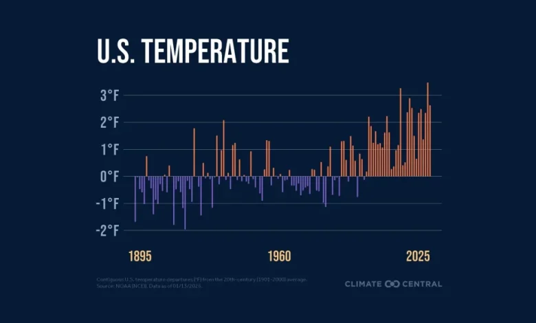
The intersection of weather and climate change has become undeniable. Data from the Copernicus Climate Change Service and NOAA confirms that 2025 was the third-warmest year on record, marginally cooler than 2023. Critically, the period from 2023 to 2025 averaged more than 1.5°C above pre-industrial levels, a symbolic breach of the Paris Agreement targets, albeit temporarily.
This excess heat significantly impacts global circulation patterns. The Jet Stream—a river of fast-moving air in the upper atmosphere—has shown signs of becoming wavier and slower. This “blocking” phenomenon causes weather systems to stall, leading to prolonged heatwaves or devastating floods. In 2025, this mechanism contributed to the record-breaking wildfires in Los Angeles, which caused over $60 billion in damages, and severe tornado outbreaks across the central United States.
Extreme Weather Mechanisms and Monitoring
Extreme weather events are becoming more frequent and intense due to higher ocean heat content and atmospheric moisture capacity.
Tropical Cyclones and Hurricanes
Hurricanes (or typhoons) act as massive heat engines. They draw energy from warm ocean waters (typically above 26°C). The eyewall contains the strongest winds, while the outer rainbands can spawn tornadoes hundreds of miles away. Advanced monitoring via Geostationary Operational Environmental Satellites (GOES) allows meteorologists to track vapor pressure and cloud top temperatures in real-time, improving evacuation lead times.
Polar Vortex and Winter Storms
The Polar Vortex is a large area of low pressure and cold air surrounding both of the Earth’s poles. It is typically held in place by a strong stratospheric Jet Stream. However, when the Jet Stream weakens (often due to sudden stratospheric warming), the vortex can disrupt, sending lobes of freezing Arctic air into mid-latitudes. This phenomenon is responsible for severe cold snaps in North America and Europe, challenging energy grids and infrastructure.
Key Meteorological Organizations and Infrastructure
Global weather monitoring relies on international cooperation and massive data exchange, coordinated primarily by the World Meteorological Organization (WMO).
- NOAA (National Oceanic and Atmospheric Administration): The US agency responsible for the National Weather Service. In late 2025, NOAA launched its own operational AI-driven models (AIGFS) to complement traditional forecasting.
- ECMWF (European Centre for Medium-Range Weather Forecasts): Renowned for the “Euro” model, widely considered the most accurate global NWP model. They are leading the charge in hybrid forecasting with their AIFS initiative.
- Copernicus: The European Union’s Earth observation programme, providing critical data on climate change, atmospheric composition, and land monitoring.
Future Outlook: Digital Twins and Hyper-Local Forecasting
The future of meteorology lies in Digital Twins—virtual replicas of the Earth system that allow for simulation of
Sources & References
- •
Copernicus Climate Change Service 2025 Report - •
NOAA National Centers for Environmental Information - •
Google DeepMind GraphCast Research Paper (Science, 2023) - •
NVIDIA Earth-2 Platform Documentation - •
ECMWF Annual Report 2025


4 Comments